Sloan Cemetery
Mirabile, Caldwell County, Missouri, USA
About
-
- Cemetery ID:
Members have Contributed
Advertisement
Photos


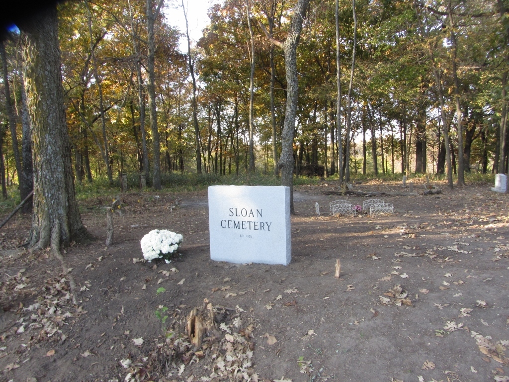
The area surrounding the cemetery is pasture land used for cattle. The rectangular 1.4 acre cemetery, however, is a natural, forested patch of land which a Sloan descendant began restoring in 2016 with initial assistance from Hamilton (Missouri) Boy Scout Troop 1836 which did a massive clearing of trees and vegetation in April.
A granite sign was installed in October 2016 to mark the entrance; look for it toward the eastern or right side of the cemetery. Running along the front of the cemetery is a ditch which must be traversed (on foot) to enter.
Parking for 4 or 5 vehicles is available off State Hwy D near the sign. That area has been grassy and efforts have been made to remove the tall grass to facilitate safe parking. Other parts of the shoulder between the Hwy and the cemetery are irregular and sloping. The dirt road on the left or western end that appears to go into the cemetery (but does not) is privately owned and used by the owner for access to his cattle and should not be used for parking.
The Cemetery of approximately 70 graves covers 1.4 acres. It is bounded by cattle fencing with about 20 feet recently removed (2016) for visitor access next to the new sign. During the April 2016 clearing by the Hamilton Boy Scouts, dead trees and a massive amount of shrubbery were removed. At least 6 of the original 12 large woodpiles of the removed trees and vegetation still await burning as of October 2016.
After the clearing in April, the cemetery was surveyed by a Boy Scout from Hamilton Troop 1836 and a 3X Great Granddaughter of Stephen and Judith Sloan who established the cemetery in 1851. This resulted in locating about 90% of the graves which were recorded in 1986 and subsequently transcribed into a list posted on USGenWeb (see below).
Because Missouri received significant rain in the summer of 2016, vegetation removed in April regrew rapidly. During July, September, and October, therefore, additional cutting and spraying with weed killer occurred in an effort to stem the growth to facilitate exploration of the cemetery by visitors.
Finding Graves
As part of the May 2016 survey, the cemetery was divided into 6 sections and given geographic designations such as SE or NW. Each Find A Grave memorial includes the designation under "Plot" if the grave was located in 2016. A map of the cemetery showing the 6 sections and grave locations is posted here as a photo and can be used to guide you to the area in which specific graves are located.
The markers of many graves consist of headstones and/or footstones. Most of these had fallen, lying flat and lightly buried in May 2016. Footstones were often reset but the headstones were too fragile, heavy, and/or broken to attempt to reset. You will therefore find two of the following types of stones at many of the graves: headstone, footstone, headstone base. Logs and branches were used to outline the graves (guided by the stones found) wherever possible but of course will deteriorate over time.
Although the cemetery is large for only 70 graves, roughly 90% of them are in just two Sections (75% in the SE Section just off the entrance and 15% in the far NW section). The remaining graves are scattered in other sections as shown on the plot map.
Because of the preponderance of graves, the SE Section is the most cleared section of the cemetery as of October 2016. Stephen and Judith Sloan are buried in this section and a new combination monument was installed in front of their original stones which were found highly deteriorated. At the grave closest to the entrance, small metal panels were placed around the stones of the grave of a Sloan who died while serving in the Civil War to help visitors avoid walking on it.
Suggestions for Visitors
If you have family buried in this cemetery or just want to visit, the following suggestions are offered to help make your visit safe and enjoyable.
1. Use the Plot Map (download the photo on this page) to guide you to graves as they are clustered in family groups for the most part. No graves were found in Section 6 (SW).
2. A ditch must be crossed to enter the cemetery by the sign. If you are fully mobile, however, this should not be a problem.
3. Outside of the SE Section (closes to entrance), most of the cemetery is still in a fairly wild condition as of October 2016. Biggest things to be cautious of are gullies and uneven terrain; lots of stumps of all sizes and heights, with the very small and short ones being hard to see and therefore easy to stub your toes on; thorny/spiny plants; and toxic plants such as poison ivy and pokeweed/pokeberry (red stems and berries in the Fall).
4. Wear enclosed shoes, long pants and shirts, and gloves. Use spray repellent with DEET for ticks (and possibly other critters) when they are most likely to be found (spring and summer).
Errors in 1986 USGenWeb List for the Sloan Cemetery
After the May 2016 survey, all persons found buried in the cemetery were researched. One important outcome was the identification of 4 errors in the transcription of the 1986 "reading" of the cemetery subsequently posted on USGenWeb. A request for corrections was sent to the site's webmaster, but no corrections have been made as of mid-November 2016. To minimize chances these errors are re-introduced, please note the following if you researching Sloan Cemetery burials:
1. Hiram Sloan: Wrong age in 1986 USGenWeb list (incorrectly stated as 10 instead of correct age of 40)
2. Minerva Swigart: Wrong age in 1986 US GenWeb list (incorrectly stated as 34 instead of correct age of 56)
3. Frank Stanley Slocum: Wrong surname in 1986 USGenWeb list (incorrectly used middle name as surname)
4. William Higman: Wrong surname in 1986 USGenWeb list (transcribed incorrectly as Holman)
Nearby cemeteries

Polo, Caldwell County, Missouri, USA
- Total memorials1k+
- Percent photographed69%
- Percent with GPS21%

Caldwell County, Missouri, USA
- Total memorials6
- Percent photographed100%
- Percent with GPS50%

Rockford Township, Caldwell County, Missouri, USA
- Total memorials42
- Percent photographed55%
- Percent with GPS0%

Caldwell County, Missouri, USA
- Total memorials24
- Percent photographed50%
- Percent with GPS0%
- Added: 1 Jan 2000
- Find a Grave Cemetery ID: 31633

Cemetery Photos
This is a carousel with slides. Use Next and Previous buttons to navigate, or jump to a slide with the slide dots. Use Escape keyboard button or the Close button to close the carousel.


Success
Uploading...
Waiting...
Failed
This photo was not uploaded because this cemetery already has 20 photos
This photo was not uploaded because you have already uploaded 5 photos to this cemetery
This photo was not uploaded because you have already uploaded 5 photos to this cemetery
Invalid File Type
Birth and death years unknown.
1 photo picked...
2 photos picked...
Uploading 1 Photo
Uploading 2 Photos
1 Photo Uploaded
2 Photos Uploaded
Size exceeded
Too many photos have been uploaded
"Unsupported file type"
• ##count## of 0 memorials with GPS displayed. Double click on map to view more.No cemeteries found