Saint Austin Cemetery
Mobile, Mobile County, Alabama, USA
About
-
Get directions 2252 Dr. Martin Luther King Jr. Avenue
Mobile, Alabama, USACoordinates: 30.71756, -88.08001 - Cemetery ID:
Members have Contributed
Advertisement
Photos


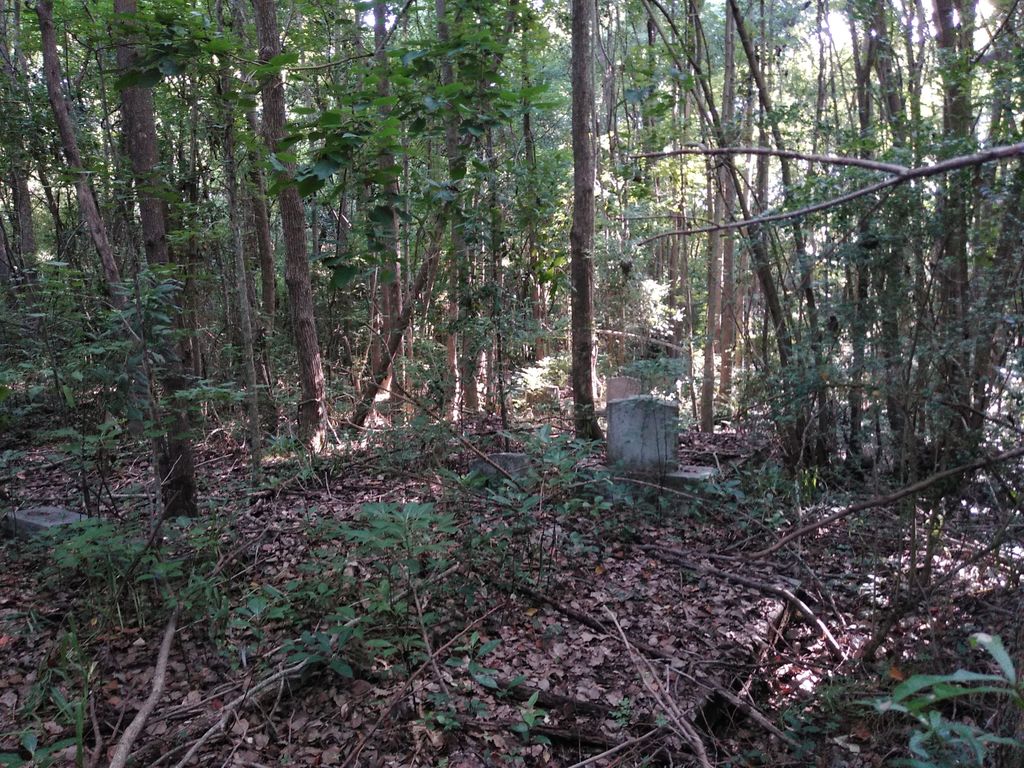
This is a historically important African American private non perpetual care cemetery on approximately 2.97 acres located in the City of Mobile. There is no known office or signage marking the cemetery, the entrance or street number. The cemetery is believed to have its origins in the mid to late 1800's serving the African American community in the Toulminville area of the City and County of Mobile. Anecdotal reports have indicated that there are pre 1900's grave markers but no systematic documentation of the grave markers has taken place at this time (1/2021) due to the limited access and the challenging conditions of the cemetery. Over time the cemetery became bounded by a residential neighborhood and access to the cemetery is limited to a narrow 30' wide strip of land (essentially an alleyway) between businesses fronting on Dr. Martin Luther King Jr. Avenue (formerly Stone Street) and behind homes that abut both sides of this alleyway. According to the City and County this land strip (alleyway) is a part of and attached to the same land the cemetery is located on. There is no designated parking in the area other than on the 30' wide "alleway". The alleyway is approximately 500' long before one arrives at the cemetery proper. However, about 230' is open for a vehicle to drive on and the remaining distance can be walkable between the residences on either side depending on how dense the brush, vines and tree growth is. The cemetery proper is heavily overgrown and the ground is extremely difficult to walk on, as many vaults, headstones (fallen, buried, etc.), dense and fallen brush/trees as well as broken vault covers are a serious trip/fall hazard.
The GPS for the "driveway" is approximately 30.716538, -88.081803
Nearby cemeteries

Mobile, Mobile County, Alabama, USA
- Total memorials10k+
- Percent photographed63%
- Percent with GPS61%

Mobile, Mobile County, Alabama, USA
- Total memorials10k+
- Percent photographed80%
- Percent with GPS44%

Mobile, Mobile County, Alabama, USA
- Total memorials4k+
- Percent photographed66%
- Percent with GPS44%
Mobile County, Alabama, USA
- Total memorials6
- Percent photographed0%
- Percent with GPS0%
- Added: 1 Jan 2000
- Find a Grave Cemetery ID: 25954

Cemetery Photos
This is a carousel with slides. Use Next and Previous buttons to navigate, or jump to a slide with the slide dots. Use Escape keyboard button or the Close button to close the carousel.


Success
Uploading...
Waiting...
Failed
This photo was not uploaded because this cemetery already has 20 photos
This photo was not uploaded because you have already uploaded 5 photos to this cemetery
This photo was not uploaded because you have already uploaded 5 photos to this cemetery
Invalid File Type
Birth and death years unknown.
1 photo picked...
2 photos picked...
Uploading 1 Photo
Uploading 2 Photos
1 Photo Uploaded
2 Photos Uploaded
Size exceeded
Too many photos have been uploaded
"Unsupported file type"
• ##count## of 0 memorials with GPS displayed. Double click on map to view more.No cemeteries found