Lutheran Cemetery at Osterburg
Also known as Saint Peters Cemetery
Osterburg, Bedford County, Pennsylvania, USA
About
-
- Cemetery ID:
Members have Contributed
Advertisement
Photos


1898 Bedford Gazette:
Lutheran Cemetery near [town of] St. Clairsville.
2013 Bedford Co. Vistors Bureau "Bedford County Cemeteries":
St. Peter's Lutheran Cemetery. Pg. 52
***********************
Maps for this cemetery are on William D. Hammer's memorial
#141687286.
***********************
This cemetery is located in East St. Clair Twp. (though it is usually sited as being in King Twp.) with the town of St. Clairsville (founded about 1820 on land owned by Henry Beckley) being the earlier town before Osterburg (founded 1876 by William Oster). Both St. Clairsville & Osterburg are used in describing the location of this cemetery. The town of St. Clairsville is in East St. Clair Twp. & Osterburg is almost completely in King Twp. but does touch the line of East St. Clair Twp. There is a newer third community, Churchville, which may refer to the area of the cemeteries & their churches.
Three cemeteries are connected with the original union church, Bobs Creek Reformed & Lutheran Church, which was founded about 1812 [or1819] with a log church built about 1824. The split between the denominations occurred about 1870. The first cemetery is the the Bob's Creek Cemetery now known as Old Union at Osterburg, with the second & third cemeteries being the Reformed Cemetery & the Lutheran Cemetery.
The Bedford County Visitors Bureau published a small booklet for $10 in 2013 named Bedford County Cemeteries.
It has given the current name for the Lutheran Cemetery at Osterburg as St. Peters Cemetery.
Directions:
From Bedford travel north on I-99 for 6.7 Miles to the Osterburg/St. Clairsville Exit/Exit 7.
At the end of the ramp turn left onto PA869 and drive .2 miles to an intersection. Turn right to stay on PA869/Old220/William Penn Rd.
Travel 1.2 miles & make a right unto Churchville Rd which is just after the bank. Travel .1 mile & make a right onto Main St. Travel .1 mile & turn left unto Grabill Rd. The Church with its cemetery is on the left.
Locations is this area are confusing because both East St. Clair Twp. & King Twp. meet here. There are three small villages coming off of I-99 which are St. Clairsville, Churchville, & Osterburg. Main Steet runs though St. Clairsville & Churchville This is a very small area of about 3 miles with a lot of history but depending on the time period, different terms were used for locations, churches, cemeteries, & roads.
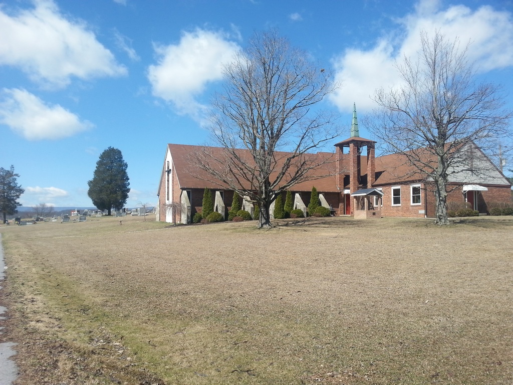
The Lutheran cemetery is located behind St. Peter's Evangelical Lutheran Church, and is directly east of what is now on Findagrave as Trinity United Church of Christ Cemetery. That cemetery was originally known as the Reformed Cemetery of Osterburg and it wraps around what was the Reformed church. Trinity United Church of Christ has again adopted the name Trinity Reformed Church.
St. Peter's Evangelical Lutheran Church which has the Lutheran Cemetery of Osterburg behind it, is the offshoot of the 1870/1871 split between the Reformed & Lutherans of Bob's Creek Reformed & Lutheran Church, the union church.
At the same time the Lutherans separated, a new church just for the Reformed was built about 1870 & was dedicated June 25, 1871. With the building of the new church in 1870, it was decided to adopt the name of Trinity Evangelical & Reformed Church rather than using Bob's Creek Church with their new cemetery being consecrated on Nov. 6, 1871. On April 29, 1915, lightning struck the church, with the church & records being destroyed. A new church was built and on May 7, 1918 it was dedicated. Joseph P. Imler was the contractor with Jacob Long, Levi Roudabush, & Frank Custer on the building committee. This was the third building for the Reformed congregation.
Across from the Trinity Reformed Cemetery of Osterburg is Old Union at Osterburg. It is reported that some of the stones from Old Union at Osterburg, when old Route 220 was built through Osterburg, were moved to the Lutheran Cemetery. Old Union is the cemetery for the original union church, Bob's Creek Reformed & Lutheran Church, and in early times was referred to as Bob's Creek Cemetery.
Bobs Creek Reformed & Lutheran church was founded about 1819 as a union church & was served by Rev. John Henry Gerhart until 1836. The building committee for this log church for the Reformed was John Berkheimer & Philip Crissman. For the Lutherans, the building committee was Jacob Berkheimer & Conrad Claycomb. There is no surviving photograph of this church. The cemetery for this union church is on Findagrave as Old Union at Osterburg. With the separation of Reformed & Lutherans the log church was sold.
Information is from:
[1.] A Century and a Quarter
A Brief History of Trinity Evangelical and Reformed Church 1819-1944 by D.W.S. based on a history done by Reverend J. W. Bechtel done in 1936-Frank R. King Printing Co. New Enterprise PA.
[2.] 1884 History of Bedford, Somerset, & Fulton Counties Pennsylvania, published by Waterman, Watkins & Co. of Chicago ILL. Pg. 286 - 288 under East St. Clair Twp.
There is an entry on Findagrave for the Community Cemetery of Osterburg with it possibly being incorporated in 1971.
This is a recent term & has been used in current obituaries. Community Cemetery of Osterburg now manages both the Reformed Cemetery & the Lutheran Cemetery. Burials that are done there now are considered to be in the Community Cemetery of Osterburg. The older detailed obituaries refer to Reformed Cem. or Lutheran Cem. There is a common paved lane with a square loop in the center that connects the two cemeteries. Both of these cemeteries are well maintained.
These cemeteries are shown in the 1877 Map of St. Clair Twp. by Beers.
1. Old Union
2. Reformed Cem.
3. Lutheran Cem.
4. Pres. Cem. - Possibly became Methodist Episcopal.
[This may have been called "Band Hall" or "Henderson" cemetery with about 14 graves. It was between the Reformed Cem. & St. Peter's Lutheran Cem.]
Locations:
Old Union at Osterburg is now located between Kansas Rd. & Heritage Rd./869 just before Slicks Ivy Stone Resturant.
The Reformed Cemetery at Osterburg is now located on Main St. just before it meets Wm. Penn Rd.
The Lutheran Cemetery is now at 175 Graybill Rd. & Kentucky Lane (near the intersection with Main street) at Osterburg.
Old Union Cemetery at Osterburg is separated from the other two by Rt. 869/Wm. Penn Rd. with the story that stones from Old Union were moved to the Lutheran Cemetery when old 220 was built. Rt. 220 has different names in different sections of the county. Part of it becomes Wm. Penn Rd/869. The cemetery is at the split where Wm. Penn Rd/Imler Valley Rd goes straight & Heritage Road/Rt. 869 wraps around the cemetery.
See maps on William D. Hammers memorial.
Find A Grave Memorial# 141687286
1898 Bedford Gazette:
Lutheran Cemetery near [town of] St. Clairsville.
2013 Bedford Co. Vistors Bureau "Bedford County Cemeteries":
St. Peter's Lutheran Cemetery. Pg. 52
***********************
Maps for this cemetery are on William D. Hammer's memorial
#141687286.
***********************
This cemetery is located in East St. Clair Twp. (though it is usually sited as being in King Twp.) with the town of St. Clairsville (founded about 1820 on land owned by Henry Beckley) being the earlier town before Osterburg (founded 1876 by William Oster). Both St. Clairsville & Osterburg are used in describing the location of this cemetery. The town of St. Clairsville is in East St. Clair Twp. & Osterburg is almost completely in King Twp. but does touch the line of East St. Clair Twp. There is a newer third community, Churchville, which may refer to the area of the cemeteries & their churches.
Three cemeteries are connected with the original union church, Bobs Creek Reformed & Lutheran Church, which was founded about 1812 [or1819] with a log church built about 1824. The split between the denominations occurred about 1870. The first cemetery is the the Bob's Creek Cemetery now known as Old Union at Osterburg, with the second & third cemeteries being the Reformed Cemetery & the Lutheran Cemetery.
The Bedford County Visitors Bureau published a small booklet for $10 in 2013 named Bedford County Cemeteries.
It has given the current name for the Lutheran Cemetery at Osterburg as St. Peters Cemetery.
Directions:
From Bedford travel north on I-99 for 6.7 Miles to the Osterburg/St. Clairsville Exit/Exit 7.
At the end of the ramp turn left onto PA869 and drive .2 miles to an intersection. Turn right to stay on PA869/Old220/William Penn Rd.
Travel 1.2 miles & make a right unto Churchville Rd which is just after the bank. Travel .1 mile & make a right onto Main St. Travel .1 mile & turn left unto Grabill Rd. The Church with its cemetery is on the left.
Locations is this area are confusing because both East St. Clair Twp. & King Twp. meet here. There are three small villages coming off of I-99 which are St. Clairsville, Churchville, & Osterburg. Main Steet runs though St. Clairsville & Churchville This is a very small area of about 3 miles with a lot of history but depending on the time period, different terms were used for locations, churches, cemeteries, & roads.
The Lutheran cemetery is located behind St. Peter's Evangelical Lutheran Church, and is directly east of what is now on Findagrave as Trinity United Church of Christ Cemetery. That cemetery was originally known as the Reformed Cemetery of Osterburg and it wraps around what was the Reformed church. Trinity United Church of Christ has again adopted the name Trinity Reformed Church.
St. Peter's Evangelical Lutheran Church which has the Lutheran Cemetery of Osterburg behind it, is the offshoot of the 1870/1871 split between the Reformed & Lutherans of Bob's Creek Reformed & Lutheran Church, the union church.
At the same time the Lutherans separated, a new church just for the Reformed was built about 1870 & was dedicated June 25, 1871. With the building of the new church in 1870, it was decided to adopt the name of Trinity Evangelical & Reformed Church rather than using Bob's Creek Church with their new cemetery being consecrated on Nov. 6, 1871. On April 29, 1915, lightning struck the church, with the church & records being destroyed. A new church was built and on May 7, 1918 it was dedicated. Joseph P. Imler was the contractor with Jacob Long, Levi Roudabush, & Frank Custer on the building committee. This was the third building for the Reformed congregation.
Across from the Trinity Reformed Cemetery of Osterburg is Old Union at Osterburg. It is reported that some of the stones from Old Union at Osterburg, when old Route 220 was built through Osterburg, were moved to the Lutheran Cemetery. Old Union is the cemetery for the original union church, Bob's Creek Reformed & Lutheran Church, and in early times was referred to as Bob's Creek Cemetery.
Bobs Creek Reformed & Lutheran church was founded about 1819 as a union church & was served by Rev. John Henry Gerhart until 1836. The building committee for this log church for the Reformed was John Berkheimer & Philip Crissman. For the Lutherans, the building committee was Jacob Berkheimer & Conrad Claycomb. There is no surviving photograph of this church. The cemetery for this union church is on Findagrave as Old Union at Osterburg. With the separation of Reformed & Lutherans the log church was sold.
Information is from:
[1.] A Century and a Quarter
A Brief History of Trinity Evangelical and Reformed Church 1819-1944 by D.W.S. based on a history done by Reverend J. W. Bechtel done in 1936-Frank R. King Printing Co. New Enterprise PA.
[2.] 1884 History of Bedford, Somerset, & Fulton Counties Pennsylvania, published by Waterman, Watkins & Co. of Chicago ILL. Pg. 286 - 288 under East St. Clair Twp.
There is an entry on Findagrave for the Community Cemetery of Osterburg with it possibly being incorporated in 1971.
This is a recent term & has been used in current obituaries. Community Cemetery of Osterburg now manages both the Reformed Cemetery & the Lutheran Cemetery. Burials that are done there now are considered to be in the Community Cemetery of Osterburg. The older detailed obituaries refer to Reformed Cem. or Lutheran Cem. There is a common paved lane with a square loop in the center that connects the two cemeteries. Both of these cemeteries are well maintained.
These cemeteries are shown in the 1877 Map of St. Clair Twp. by Beers.
1. Old Union
2. Reformed Cem.
3. Lutheran Cem.
4. Pres. Cem. - Possibly became Methodist Episcopal.
[This may have been called "Band Hall" or "Henderson" cemetery with about 14 graves. It was between the Reformed Cem. & St. Peter's Lutheran Cem.]
Locations:
Old Union at Osterburg is now located between Kansas Rd. & Heritage Rd./869 just before Slicks Ivy Stone Resturant.
The Reformed Cemetery at Osterburg is now located on Main St. just before it meets Wm. Penn Rd.
The Lutheran Cemetery is now at 175 Graybill Rd. & Kentucky Lane (near the intersection with Main street) at Osterburg.
Old Union Cemetery at Osterburg is separated from the other two by Rt. 869/Wm. Penn Rd. with the story that stones from Old Union were moved to the Lutheran Cemetery when old 220 was built. Rt. 220 has different names in different sections of the county. Part of it becomes Wm. Penn Rd/869. The cemetery is at the split where Wm. Penn Rd/Imler Valley Rd goes straight & Heritage Road/Rt. 869 wraps around the cemetery.
See maps on William D. Hammers memorial.
Find A Grave Memorial# 141687286
Nearby cemeteries

Osterburg, Bedford County, Pennsylvania, USA
- Total memorials296
- Percent photographed84%
- Percent with GPS3%

Osterburg, Bedford County, Pennsylvania, USA
- Total memorials848
- Percent photographed94%
- Percent with GPS1%

Osterburg, Bedford County, Pennsylvania, USA
- Total memorials391
- Percent photographed88%
- Percent with GPS5%
King Township, Bedford County, Pennsylvania, USA
- Total memorials3
- Percent photographed0%
- Added: 23 Jan 2015
- Find a Grave Cemetery ID: 2566779

Cemetery Photos
This is a carousel with slides. Use Next and Previous buttons to navigate, or jump to a slide with the slide dots. Use Escape keyboard button or the Close button to close the carousel.


Success
Uploading...
Waiting...
Failed
This photo was not uploaded because this cemetery already has 20 photos
This photo was not uploaded because you have already uploaded 5 photos to this cemetery
This photo was not uploaded because you have already uploaded 5 photos to this cemetery
Invalid File Type
Birth and death years unknown.
1 photo picked...
2 photos picked...
Uploading 1 Photo
Uploading 2 Photos
1 Photo Uploaded
2 Photos Uploaded
Size exceeded
Too many photos have been uploaded
"Unsupported file type"
• ##count## of 0 memorials with GPS displayed. Double click on map to view more.No cemeteries found