Sober Hill Cemetery
Leechburg, Armstrong County, Pennsylvania, USA
About
-
Get directions State Route 2082 (Schenley Road)
Leechburg, Pennsylvania 15656 United StatesCoordinates: 40.66508, -79.62452 - Cemetery ID:
Members have Contributed
Advertisement
Photos


The history of the cemetery is mostly lost, the Hill Family owned the property and have the most graves there. It could be the only cemetery in the area and was a community wide burial site. Most of the neighbors were also related to the Hill Family.
The Sober connection is that Daniel N Sober bought the property in 1909 from the Hill family and forever after was called the Sober-Hill Cemetery.
The Sober Hill Cemetery is located on the (Old Hill Family Farm) off State Route 2082, also known as (The New Schenley Road) in Gilpin Twp, Armstrong Co., PA.
The cemetery is a distance directly behind the Hill Farm house, which is located on the (now Sober Road) as known as the Old Schenley Road.
There are two levels to this cemetery, the first one is on the very top of the hill with at least seven graves,and there are more unmarked graves located there.
The second one is a small distance down the hill with at least four burials, and there are more unmarked graves located there.
The Sober Hill Family Farm is located on the Old Schenley Road, (now called Sober Road), about 1/4 mile from junction of Sober Road and Bagdad Road.
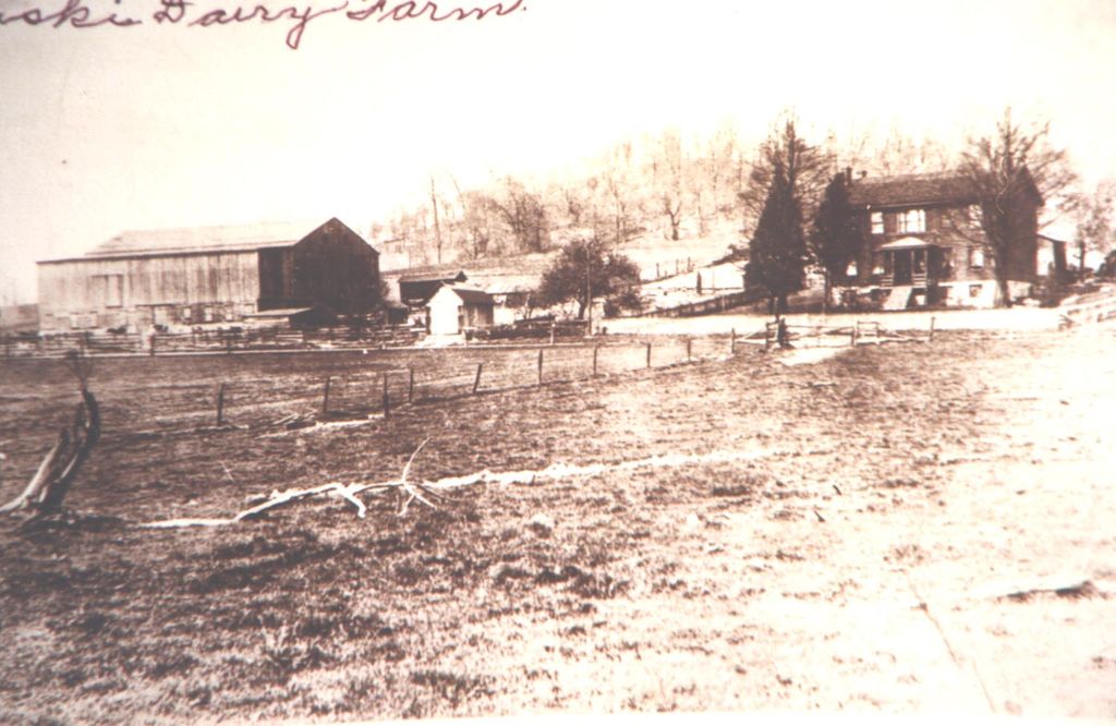
This is the house started in 1848 by John Squire Hill and finished by his son, Daniel Hill & wife Elizabeth Jane Kuhns Hill in 1849.
This farm was bought by my Great Grandfather, Daniel Newton Sober in 1909 at a sheriff sale for taxes
The photo was taken about 1925, it was called (The Kiski Diary Farm) then.
The data base used here is from (PA-ROOTS.COM)
Some of the dates of birth were calculated using the www.progenealogists.com Birth Date Calculator.
(Information added by Burke Stoughton)
You might wish to note that the marker for John Hill is the large square base to the right of the marker leaning up against the tree. This base had a large obelisk type stone on it and it is laying, to the right of the base. The marker leaning up against the tree is Harriet Hill and Elizabeth Hill's marker is under the brush, in the fork, of the downed tree. Basically this is all that is left of the Sober Hill Cemetery.
The history of the cemetery is mostly lost, the Hill Family owned the property and have the most graves there. It could be the only cemetery in the area and was a community wide burial site. Most of the neighbors were also related to the Hill Family.
The Sober connection is that Daniel N Sober bought the property in 1909 from the Hill family and forever after was called the Sober-Hill Cemetery.
The Sober Hill Cemetery is located on the (Old Hill Family Farm) off State Route 2082, also known as (The New Schenley Road) in Gilpin Twp, Armstrong Co., PA.
The cemetery is a distance directly behind the Hill Farm house, which is located on the (now Sober Road) as known as the Old Schenley Road.
There are two levels to this cemetery, the first one is on the very top of the hill with at least seven graves,and there are more unmarked graves located there.
The second one is a small distance down the hill with at least four burials, and there are more unmarked graves located there.
The Sober Hill Family Farm is located on the Old Schenley Road, (now called Sober Road), about 1/4 mile from junction of Sober Road and Bagdad Road.
This is the house started in 1848 by John Squire Hill and finished by his son, Daniel Hill & wife Elizabeth Jane Kuhns Hill in 1849.
This farm was bought by my Great Grandfather, Daniel Newton Sober in 1909 at a sheriff sale for taxes
The photo was taken about 1925, it was called (The Kiski Diary Farm) then.
The data base used here is from (PA-ROOTS.COM)
Some of the dates of birth were calculated using the www.progenealogists.com Birth Date Calculator.
(Information added by Burke Stoughton)
You might wish to note that the marker for John Hill is the large square base to the right of the marker leaning up against the tree. This base had a large obelisk type stone on it and it is laying, to the right of the base. The marker leaning up against the tree is Harriet Hill and Elizabeth Hill's marker is under the brush, in the fork, of the downed tree. Basically this is all that is left of the Sober Hill Cemetery.
Nearby cemeteries
Gilpin Township, Armstrong County, Pennsylvania, USA
- Total memorials1
- Percent photographed100%

Leechburg, Armstrong County, Pennsylvania, USA
- Total memorials2k+
- Percent photographed79%
- Percent with GPS4%

Leechburg, Armstrong County, Pennsylvania, USA
- Total memorials15
- Percent photographed20%
- Percent with GPS80%

Leechburg, Armstrong County, Pennsylvania, USA
- Total memorials3k+
- Percent photographed76%
- Percent with GPS0%
- Added: 13 Oct 2009
- Find a Grave Cemetery ID: 2327102

Cemetery Photos
This is a carousel with slides. Use Next and Previous buttons to navigate, or jump to a slide with the slide dots. Use Escape keyboard button or the Close button to close the carousel.


Success
Uploading...
Waiting...
Failed
This photo was not uploaded because this cemetery already has 20 photos
This photo was not uploaded because you have already uploaded 5 photos to this cemetery
This photo was not uploaded because you have already uploaded 5 photos to this cemetery
Invalid File Type
Birth and death years unknown.
1 photo picked...
2 photos picked...
Uploading 1 Photo
Uploading 2 Photos
1 Photo Uploaded
2 Photos Uploaded
Size exceeded
Too many photos have been uploaded
"Unsupported file type"
• ##count## of 0 memorials with GPS displayed. Double click on map to view more.No cemeteries found