St. George-in-the-East Churchyard
Stepney, London Borough of Tower Hamlets, Greater London, England
About
-
Get directions Cannon Street Road
Stepney, London Borough of Tower Hamlets, Greater London E1 0BH EnglandCoordinates: 51.50996, -0.05991 - Cemetery ID:
Members have Contributed
Advertisement
Photos


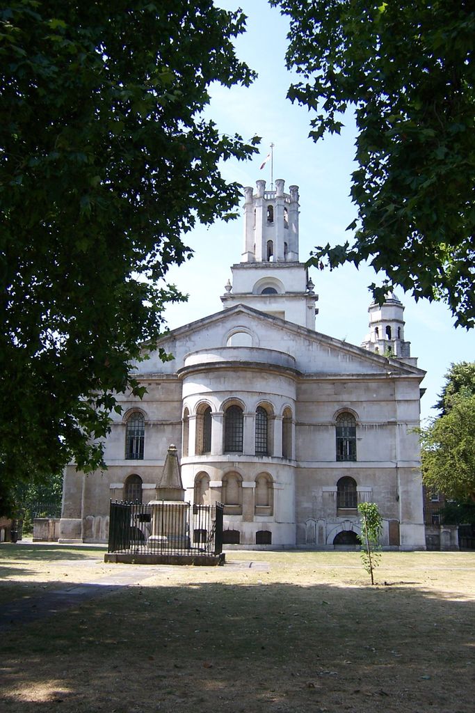
Hidden from view by perimeter development, the lantern tower of St George-in-the-East has provided a historic focal point for the parish and a prominent feature on the Borough's skyline. Visual permeability through the area has been improved by the demolition of buildings lining The Highway. Although altering the historic presentation and, to a certain extent, the address of the church, the exposure has also increased passive surveillance and public use of the gardens.
Character
Until the Blitz in 1940, the south side of St George-in-the-East church was always screened by housing along The Highway. At the time of construction, Hawksmoor originally tried to persuade the Commissioners to demolish and replace the houses with more appropriate precinct buildings. The former Rectory (1726-9), at the north-western corner of the church, represents the only part of Hawksmoor's Precinct Plan that was achieved. Its original street address has been lost to recent residential development. The eventual demolition of The Highway housing has provided a new formal entrance and has exposed the southern façade of the church and grounds.
St George-in-the-East has formed a landmark in this part of the Borough since its construction, and its prominence has been secured with the expansion of the gardens to the south. The church, rectory and associated walls, gates, railings and memorials form a significant group within the former churchyard. The urban character is further defined by the surrounding historic buildings lining the streets on the area's perimeter and. The setting is enhanced by 128 The Highway, which, to the other side of the Highway, provides a period counterbalance to remainder of the area.
Area History
The first documentary reference to the Shadwell area dates back to 1223 (a corruption of ‘St Chads Well'). Between the 16th & 18th centuries, a rise in the population of the many riverside communities, of which Shadwell is one, reflected a growth in the shipping and ship building industries located along the banks of the Thames, east of the City. Tiny settlements grew into distinctive villages supporting the maritime trade,and by the time Shadwell became a separate parish in 1669, the local population had grown to about 8000.
During the 17th century, churches and chapels-of-ease were being constructed in response to London's eastward spread, and in the 18th century a commission was established to implement the construction of fifty new Anglican churches in areas of population growth. The New Churches Act was passed by Parliament in 1711 and enabled money to be raised for the construction of the churches from coal tax. Of the 50 churches planned, only 12 were built to designs by architects associated with the Office of Works, including St George-in-the-East (Wapping) and St Anne (Limehouse).
These also represent two of the three Borough churches designed by architect Nicholas Hawksmoor, a pupil of Sir Christopher Wren, (the third being Christchurch, Spitalfields). Considered the most original of Hawksmoor's East-End churches, St George-in-the-East, constructed between 1714-26, was dedicated in 1729 to serve Wapping-Stepney and the area to its north. The tower was added between 1720-3, plasterwork between 1723-4 and the pews and carving in 1729. Atthe time of its construction, the surrounding area was still largely rural, with open fields to the north of the churchyard (itself occupying an area known as the Gun Field), otherwise enclosed by buildings lining the principal roads. The 18th century church yard was lined with rows of trees along the north, south and eastern boundaries, and in 1862, when further land had been added; a new layout included a Rector's Walk and Lime Avenue.
By the beginning of the 19th century, the adjacent fields and vacant land, (freed by earlier slum clearance) had been re-colonised, and a rope-making factory established to the north-east. The church and its yard were land-locked by the surrounding development, and its main entrance was through a narrow gap in the streetscape off Cannon Street Road. The church burial ground was extended in 1829 with the purchase of the rope walk, and in 1875 was amalgamated with the graveyard of St George's Methodist Church (Cable Street), forming St George's Gardens in 1886. The new public gardens had entrances off Radcliffe Street, Cannon Street Road and Cable Street. The former parish mortuary (1880) opened as the ‘Metropolitan Borough of Stepney Nature Study Museum' in 1904, providing ‘hands-on' nature education forEast End schoolchildren until it was closed in 1939.
The church and many of its surrounding buildings were gutted by fire in the 1941 bombings, the church lying derelict until the 1960s reconstruction by Ansell & Bailey, a contemporary insertion within the original (restored) shell.
Nearby cemeteries

Shadwell, London Borough of Tower Hamlets, Greater London, England
- Total memorials87
- Percent photographed40%
- Percent with GPS0%
Wapping, London Borough of Tower Hamlets, Greater London, England
- Total memorials8
- Percent photographed0%
Shadwell, London Borough of Tower Hamlets, Greater London, England
- Total memorials70
- Percent photographed0%

Wapping, London Borough of Tower Hamlets, Greater London, England
- Total memorials99
- Percent photographed55%
- Percent with GPS22%
- Added: 17 Sep 2009
- Find a Grave Cemetery ID: 2323524

Cemetery Photos
This is a carousel with slides. Use Next and Previous buttons to navigate, or jump to a slide with the slide dots. Use Escape keyboard button or the Close button to close the carousel.


Success
Uploading...
Waiting...
Failed
This photo was not uploaded because this cemetery already has 20 photos
This photo was not uploaded because you have already uploaded 5 photos to this cemetery
This photo was not uploaded because you have already uploaded 5 photos to this cemetery
Invalid File Type
Birth and death years unknown.
1 photo picked...
2 photos picked...
Uploading 1 Photo
Uploading 2 Photos
1 Photo Uploaded
2 Photos Uploaded
Size exceeded
Too many photos have been uploaded
"Unsupported file type"
• ##count## of 0 memorials with GPS displayed. Double click on map to view more.No cemeteries found