Kemmel Chateau Military Cemetery
Kemmel, Arrondissement Ieper, West Flanders, Belgium
About
-
- Cemetery ID:
Members have Contributed
Advertisement
Photos


Location Information: Kemmel Chateau Military Cemetery is located 8 kilometres south of Ieper on a road leading from the Kemmelseweg (N331), connecting Ieper to Kemmel. From Ieper town centre the Kemmelseweg is reached via the Rijselsestraat, through the Lille Gate (Rijselpoort) and straight on towards Armentieres (N336). 900 metres after the crossroads is the right hand turning onto the Kemmelseweg (made prominent by a railway level crossing). On reaching the village of Kemmel the first right hand turning leads onto the Reningelststraat. 600 metres along the Reningelststraat lies the right hand turning onto Nieuwstraat. 500 metres along the Nieuwstraat on the right hand side of the road lies the cemetery.
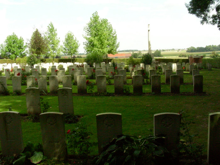
Historical Information: Kemmel Chateau was north-east of Kemmel village and the cemetery was established on the north side of the chateau grounds in December 1914. It continued to be used by divisions fighting on the southern sectors of the Belgian front until March 1918, when after fierce fighting involving both Commonwealth and French forces, the village and cemetery fell into German hands in late April. The cemetery was retaken later in the year, but in the interval it was badly shelled and the old chateau destroyed. There are now 1,135 Commonwealth burials of the First World War in the cemetery and 21 from the Second World War, all dating from the Allied withdrawal ahead of the German advance of May 1940.
The cemetery was designed by Sir Edwin Lutyens. No. of Identified Casualties: 1132
Location Information: Kemmel Chateau Military Cemetery is located 8 kilometres south of Ieper on a road leading from the Kemmelseweg (N331), connecting Ieper to Kemmel. From Ieper town centre the Kemmelseweg is reached via the Rijselsestraat, through the Lille Gate (Rijselpoort) and straight on towards Armentieres (N336). 900 metres after the crossroads is the right hand turning onto the Kemmelseweg (made prominent by a railway level crossing). On reaching the village of Kemmel the first right hand turning leads onto the Reningelststraat. 600 metres along the Reningelststraat lies the right hand turning onto Nieuwstraat. 500 metres along the Nieuwstraat on the right hand side of the road lies the cemetery.
Historical Information: Kemmel Chateau was north-east of Kemmel village and the cemetery was established on the north side of the chateau grounds in December 1914. It continued to be used by divisions fighting on the southern sectors of the Belgian front until March 1918, when after fierce fighting involving both Commonwealth and French forces, the village and cemetery fell into German hands in late April. The cemetery was retaken later in the year, but in the interval it was badly shelled and the old chateau destroyed. There are now 1,135 Commonwealth burials of the First World War in the cemetery and 21 from the Second World War, all dating from the Allied withdrawal ahead of the German advance of May 1940.
The cemetery was designed by Sir Edwin Lutyens. No. of Identified Casualties: 1132
Nearby cemeteries

Kemmel, Arrondissement Ieper, West Flanders, Belgium
- Total memorials25
- Percent photographed88%
- Percent with GPS0%

Kemmel, Arrondissement Ieper, West Flanders, Belgium
- Total memorials0
- Percent photographed0%

Kemmel, Arrondissement Ieper, West Flanders, Belgium
- Total memorials575
- Percent photographed100%
- Percent with GPS1%

Kemmel, Arrondissement Ieper, West Flanders, Belgium
- Total memorials272
- Percent photographed99%
- Percent with GPS2%
- Added: 2 Dec 2005
- Find a Grave Cemetery ID: 2159890

Cemetery Photos
This is a carousel with slides. Use Next and Previous buttons to navigate, or jump to a slide with the slide dots. Use Escape keyboard button or the Close button to close the carousel.


Success
Uploading...
Waiting...
Failed
This photo was not uploaded because this cemetery already has 20 photos
This photo was not uploaded because you have already uploaded 5 photos to this cemetery
This photo was not uploaded because you have already uploaded 5 photos to this cemetery
Invalid File Type
Birth and death years unknown.
1 photo picked...
2 photos picked...
Uploading 1 Photo
Uploading 2 Photos
1 Photo Uploaded
2 Photos Uploaded
Size exceeded
Too many photos have been uploaded
"Unsupported file type"
• ##count## of 0 memorials with GPS displayed. Double click on map to view more.No cemeteries found