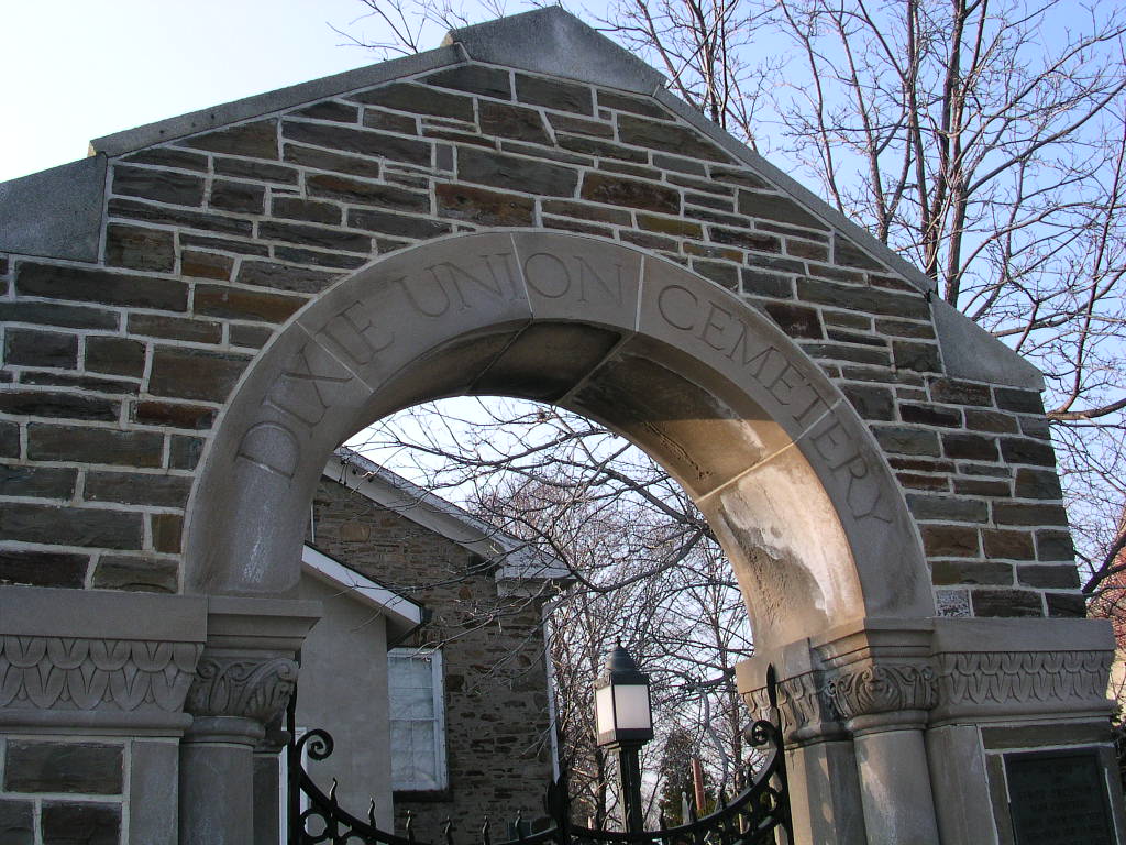
Dixie Union Chapel and Cemetery
Mississauga, Peel Regional Municipality, Ontario, Canada
About
-
Get directions 770 Dundas St E
Mississauga, Peel Regional Municipality, Ontario CanadaCoordinates: 43.59492, -79.60004 - dixieunionchapel.wordpress.com
- Cemetery ID:
Members have Contributed
Advertisement
Photos


Northeast corner of Dundas Street and Cawthra Road
In 1785, Governor John Graves Simcoe, representing the Crown, purchased lands so a "great military highway" could be established between York (Toronto) and Hamilton. This thoroughfare was named Dundas Street and lots fronting on it were granted to "men with means or influence".
Such a man was Philip Cody, a New Englander, who arrived and established Cody's Tavern and assisted Joseph Silverthorn and Allan Robinet in settling the land along Dundas Street in what is now part of the City of Mississauga. It was Cody who offered a 1 acre piece of land in 1810 so a cemetery and place of worship could be established.
The first church on the site consisted of a log cabin built by the Union Church to meet the needs of the Protestant settlers who were filling in along the new Dundas road. The cemetery behind the church was established in 1812. Methodists, Presbyterians and Anglicans worshipped at separate times each week in the building and shared in its upkeep and that of the cemetery. The log building was replaced with a stone chapel in 1837 and became known as Dixie Union Chapel and Cemetery, named after Dr. Beaumont Dixie, a country doctor who donated more land for the church.
In 1870 the Dixie Union Cemetery was divided. The original pioneer section lies beside and directly to the north behind the old Stone Church and remains known today as Dixie Union Cemetery. The land east of an old laneway (which ran parallel with Cawthra Road) and behind St. John the Baptist Anglican Church (Dixie) became St. John the Baptist Anglican Cemetery and is now known as St John's Dixie Cemetery.
In 1974, the stone chapel was designated as a historical site as it is the oldest Union Chapel in Ontario. The cemetery still has occasional new burials for people who own family plots.
Nearby cemeteries

Mississauga, Peel Regional Municipality, Ontario, Canada
- Total memorials2k+
- Percent photographed89%
- Percent with GPS6%

Mississauga, Peel Regional Municipality, Ontario, Canada
- Total memorials744
- Percent photographed80%
- Percent with GPS31%
Mississauga, Peel Regional Municipality, Ontario, Canada
- Total memorials2
- Percent photographed0%
- Percent with GPS0%

Mississauga, Peel Regional Municipality, Ontario, Canada
- Total memorials130
- Percent photographed95%
- Percent with GPS0%
- Added: 21 Jun 2013
- Find a Grave Cemetery ID: 2501403

Cemetery Photos
This is a carousel with slides. Use Next and Previous buttons to navigate, or jump to a slide with the slide dots. Use Escape keyboard button or the Close button to close the carousel.


Success
Uploading...
Waiting...
Failed
This photo was not uploaded because this cemetery already has 20 photos
This photo was not uploaded because you have already uploaded 5 photos to this cemetery
This photo was not uploaded because you have already uploaded 5 photos to this cemetery
Invalid File Type
Birth and death years unknown.
1 photo picked...
2 photos picked...
Uploading 1 Photo
Uploading 2 Photos
1 Photo Uploaded
2 Photos Uploaded
Size exceeded
Too many photos have been uploaded
"Unsupported file type"
• ##count## of 0 memorials with GPS displayed. Double click on map to view more.No cemeteries found