Chandler Cemetery
Also known as Chandler Family Cemetery
Lebanon, Wilson County, Tennessee, USA
About
-
- Cemetery ID:
Members have Contributed
Advertisement
Photos


Josiah and his sons eventually buy other adjacent and nearby lands.
The cemetery is rumored to have been a burial ground for many years before Josiah purchased the land -- our family tradition states that this area at the top of the ridge had been a previous burial location for Native Americans. Obviously, high lands were ideal for burials because flooding would never be a problem. Our family and locals we've talked to echo this "legend".
Josiah and his wife Sallie Eddins Chandler hang on my family tree twice -- as GGGGG grandparents and as GGGGGG grandparents. I'm descended from them on one line through their daughter Elizabeth Chandler and on another line through their son Rev. Jordan Chandler. Josiah fought in the Revolution for the North Carolina Continental Line and received a pension before his death in 1827, and he is buried here at Chandler Cemetery-Bettis Road.
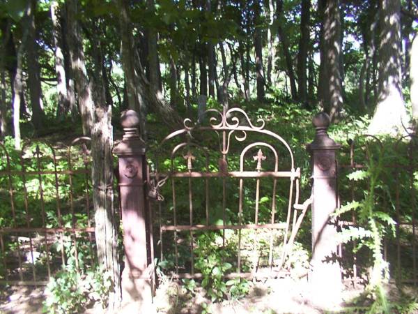
In 1906, one of Josiah's granddaughters, Sarah Paulina (Chandler) Rogers, left in her will that she wished 500$ of her estate to go to reworking the Chandler Cemetery, possibly putting up the iron gate that is in shambles today, and also possibly ordering new stones for the ones that may have been hard to identify -- even in 1906. Many of the stones strewn around this cemetery seem to be more from the 1906 era than from the 1820s, etc. Also, my understanding is that well known researcher Thomas Partlow from Wilson County obtained a Rev. War govt marker for Josiah Chandler and had it placed next to his gravestone in more recent years. My sister and I met Thomas Partlow in 2001 at the Wilson County Historical Society and he is an invaluable resource for local family history -- a great man.
In the 1920s, my grandfather, Frederick McLaughlin, visited this cemetery as a boy from Illinois. Our "Pop", who passed in 2006, knew his great grandmother Martha (Rogers) Bennett well (great granddaughter of Josiah). He told me that as a young boy, they boarded a train in Illinois and went to Tennessee and "many old ladies fussed over me for the entire visit". He was told they were all "aunts and cousins". These were Rogers and Chandler relatives.
QUICK DIRECTIONS: Do a map search online for Bettis Road, follow it north until it dead-ends straight into a gate with stone walls to both sides. Keep in mind, this IS private property, but the gate has been open the few times we've attempted to visit the cemetery.
FROM HARRIET, WHO WAS HERE FEB. 2012: I would suggest that, rather than sending folks cross-country through an unforewarned owner's pasture, one might stay on the driving path through the field, all the way to the cemetery. Better PR in the long run, and not as many blackberry bushes.
This lane, dim but still visible in closeup satellite view (on Google Earth), bears left (NNW) as you leave the gate, and climbs the first, steep hill. That places the first grove of trees to your right, and the pond just NW of the trees. Good so far.
The path then proceeds north and more gradually up the ridge, taking a slight (soggy as of Feb 3, 2012) dip as it passes uphill and west of the pond. Passing through a bunch of blackberries, the cut is visible in satellite view, it then curves right (east), back toward a second, taller, northeastern hilltop with very large grove of trees. The path runs within probably 30 feet west of the entrance to the cemetery, and appears to end just north, because the hill drops off steeply into the next gulch.
Josiah and his sons eventually buy other adjacent and nearby lands.
The cemetery is rumored to have been a burial ground for many years before Josiah purchased the land -- our family tradition states that this area at the top of the ridge had been a previous burial location for Native Americans. Obviously, high lands were ideal for burials because flooding would never be a problem. Our family and locals we've talked to echo this "legend".
Josiah and his wife Sallie Eddins Chandler hang on my family tree twice -- as GGGGG grandparents and as GGGGGG grandparents. I'm descended from them on one line through their daughter Elizabeth Chandler and on another line through their son Rev. Jordan Chandler. Josiah fought in the Revolution for the North Carolina Continental Line and received a pension before his death in 1827, and he is buried here at Chandler Cemetery-Bettis Road.
In 1906, one of Josiah's granddaughters, Sarah Paulina (Chandler) Rogers, left in her will that she wished 500$ of her estate to go to reworking the Chandler Cemetery, possibly putting up the iron gate that is in shambles today, and also possibly ordering new stones for the ones that may have been hard to identify -- even in 1906. Many of the stones strewn around this cemetery seem to be more from the 1906 era than from the 1820s, etc. Also, my understanding is that well known researcher Thomas Partlow from Wilson County obtained a Rev. War govt marker for Josiah Chandler and had it placed next to his gravestone in more recent years. My sister and I met Thomas Partlow in 2001 at the Wilson County Historical Society and he is an invaluable resource for local family history -- a great man.
In the 1920s, my grandfather, Frederick McLaughlin, visited this cemetery as a boy from Illinois. Our "Pop", who passed in 2006, knew his great grandmother Martha (Rogers) Bennett well (great granddaughter of Josiah). He told me that as a young boy, they boarded a train in Illinois and went to Tennessee and "many old ladies fussed over me for the entire visit". He was told they were all "aunts and cousins". These were Rogers and Chandler relatives.
QUICK DIRECTIONS: Do a map search online for Bettis Road, follow it north until it dead-ends straight into a gate with stone walls to both sides. Keep in mind, this IS private property, but the gate has been open the few times we've attempted to visit the cemetery.
FROM HARRIET, WHO WAS HERE FEB. 2012: I would suggest that, rather than sending folks cross-country through an unforewarned owner's pasture, one might stay on the driving path through the field, all the way to the cemetery. Better PR in the long run, and not as many blackberry bushes.
This lane, dim but still visible in closeup satellite view (on Google Earth), bears left (NNW) as you leave the gate, and climbs the first, steep hill. That places the first grove of trees to your right, and the pond just NW of the trees. Good so far.
The path then proceeds north and more gradually up the ridge, taking a slight (soggy as of Feb 3, 2012) dip as it passes uphill and west of the pond. Passing through a bunch of blackberries, the cut is visible in satellite view, it then curves right (east), back toward a second, taller, northeastern hilltop with very large grove of trees. The path runs within probably 30 feet west of the entrance to the cemetery, and appears to end just north, because the hill drops off steeply into the next gulch.
Nearby cemeteries
Wilson County, Tennessee, USA
- Total memorials5
- Percent photographed20%
- Percent with GPS20%

Wilson County, Tennessee, USA
- Total memorials30
- Percent photographed70%
- Percent with GPS0%

Gladeville, Wilson County, Tennessee, USA
- Total memorials21
- Percent photographed86%
- Percent with GPS0%

Wilson County, Tennessee, USA
- Total memorials8
- Percent photographed100%
- Percent with GPS0%
- Added: 29 Aug 2008
- Find a Grave Cemetery ID: 2274128

Cemetery Photos
This is a carousel with slides. Use Next and Previous buttons to navigate, or jump to a slide with the slide dots. Use Escape keyboard button or the Close button to close the carousel.


Success
Uploading...
Waiting...
Failed
This photo was not uploaded because this cemetery already has 20 photos
This photo was not uploaded because you have already uploaded 5 photos to this cemetery
This photo was not uploaded because you have already uploaded 5 photos to this cemetery
Invalid File Type
Birth and death years unknown.
1 photo picked...
2 photos picked...
Uploading 1 Photo
Uploading 2 Photos
1 Photo Uploaded
2 Photos Uploaded
Size exceeded
Too many photos have been uploaded
"Unsupported file type"
• ##count## of 0 memorials with GPS displayed. Double click on map to view more.No cemeteries found