Hangman Trail Burial Ground
Heber, Navajo County, Arizona, USA
About
-
- Cemetery ID:
Members have Contributed
Advertisement
Photos


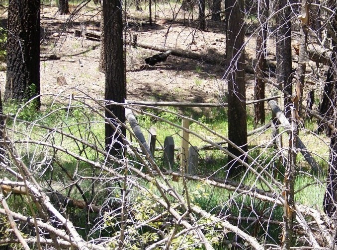
These graves are in a remote, isolated location along the Black Canyon Trail which is also identified as Forest Road 86 in the Apache-Sitgreaves National Forest. From Payson the trail is accessed just east of Forest Lakes and .1 mile east of mile marker 291 on Arizona 260 and is clearly marked. Turn right and follow the signs. From Show Low and other easterly destinations the trail is accessed as Black Canyon Trail and is the last road in Heber just before Arizona 260 starts up the hill. Turn left and stay on FR 86. The trail is 16.8 miles long and 16.3 miles is unpaved, but easily traversed by the family SUV. The entire trail is worthy of visiting and the beauty is marred only by the scaring of the Rodeo-Chedeski fire. The graves are located near the end of trail closest to the Forest Lakes entry. When you see a sign identifying Auto tour Number 7 and/or the Hangman Trail park you vehicle. The graves are located one mile up Hangman Trail which is closed to all vehicular traffic. It is an easy hike with an upward slope going to the graves and downhill coming back. You might even see some deer and other wild life.
These graves are in a remote, isolated location along the Black Canyon Trail which is also identified as Forest Road 86 in the Apache-Sitgreaves National Forest. From Payson the trail is accessed just east of Forest Lakes and .1 mile east of mile marker 291 on Arizona 260 and is clearly marked. Turn right and follow the signs. From Show Low and other easterly destinations the trail is accessed as Black Canyon Trail and is the last road in Heber just before Arizona 260 starts up the hill. Turn left and stay on FR 86. The trail is 16.8 miles long and 16.3 miles is unpaved, but easily traversed by the family SUV. The entire trail is worthy of visiting and the beauty is marred only by the scaring of the Rodeo-Chedeski fire. The graves are located near the end of trail closest to the Forest Lakes entry. When you see a sign identifying Auto tour Number 7 and/or the Hangman Trail park you vehicle. The graves are located one mile up Hangman Trail which is closed to all vehicular traffic. It is an easy hike with an upward slope going to the graves and downhill coming back. You might even see some deer and other wild life.
Nearby cemeteries

Heber, Navajo County, Arizona, USA
- Total memorials6
- Percent photographed83%
- Percent with GPS0%
Young, Gila County, Arizona, USA
- Total memorials1
- Percent photographed100%
- Percent with GPS0%
Gila County, Arizona, USA
- Total memorials4
- Percent photographed100%
- Percent with GPS0%

Heber, Navajo County, Arizona, USA
- Total memorials603
- Percent photographed94%
- Percent with GPS49%
- Added: 22 May 2007
- Find a Grave Cemetery ID: 2218004

Cemetery Photos
This is a carousel with slides. Use Next and Previous buttons to navigate, or jump to a slide with the slide dots. Use Escape keyboard button or the Close button to close the carousel.


Success
Uploading...
Waiting...
Failed
This photo was not uploaded because this cemetery already has 20 photos
This photo was not uploaded because you have already uploaded 5 photos to this cemetery
This photo was not uploaded because you have already uploaded 5 photos to this cemetery
Invalid File Type
Birth and death years unknown.
1 photo picked...
2 photos picked...
Uploading 1 Photo
Uploading 2 Photos
1 Photo Uploaded
2 Photos Uploaded
Size exceeded
Too many photos have been uploaded
"Unsupported file type"
• ##count## of 0 memorials with GPS displayed. Double click on map to view more.No cemeteries found