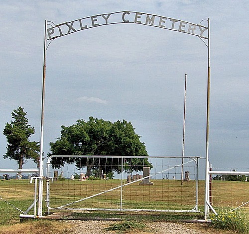
Pixley Cemetery
Fairfax, Osage County, Oklahoma, USA
A peninsula created by the twisting of the Arkansas river. To reach the cemetery;
Leave Fairfax on the old Ponca City road (River Road) West.
Nine miles, Turn South 1 mile then turn back West for three miles. At this time is a tank battery on the left side of the road that almost obscures the turn to the left. Take the road to the top of the hill and the cemetery is located on the crest, to the right.
A record of the names on the stones was made in 1986.
A few names have been added from personal knowledge of relatives. The original work is on file with the Fairfax Genealogical Society. There are several unmarked graves and one unreadable stone. Some markers were only sandstone with scratched initials. A written record was once kept but it's location has not been discovered.
Nearby cemeteries

Noble County, Oklahoma, USA
- Total memorials20
- Percent photographed75%
- Percent with GPS0%

Red Rock, Noble County, Oklahoma, USA
- Total memorials42
- Percent photographed90%
- Percent with GPS19%

Red Rock, Noble County, Oklahoma, USA
- Total memorials1k+
- Percent photographed78%
- Percent with GPS12%

Masham, Pawnee County, Oklahoma, USA
- Total memorials655
- Percent photographed94%
- Percent with GPS5%
- Added: 28 Oct 2006
- Find a Grave Cemetery ID: 2194629

Cemetery Photos
This is a carousel with slides. Use Next and Previous buttons to navigate, or jump to a slide with the slide dots. Use Escape keyboard button or the Close button to close the carousel.
Success
Uploading...
Waiting...
Failed
This photo was not uploaded because this cemetery already has 20 photos
This photo was not uploaded because you have already uploaded 5 photos to this cemetery
This photo was not uploaded because you have already uploaded 5 photos to this cemetery
Invalid File Type
Birth and death years unknown.
1 photo picked...
2 photos picked...
Uploading 1 Photo
Uploading 2 Photos
1 Photo Uploaded
2 Photos Uploaded
Size exceeded
Too many photos have been uploaded
"Unsupported file type"
• ##count## of 0 memorials with GPS displayed. Double click on map to view more.No cemeteries found