Camino Cemetery
Also known as Crystal Springs Cemetery , Hamilton Cemetery , Hartwick Cemetery , Nine Mile House Cemetery
Camino, El Dorado County, California, USA
About
-
- Cemetery ID:
Members have Contributed
Advertisement
Photos


History:
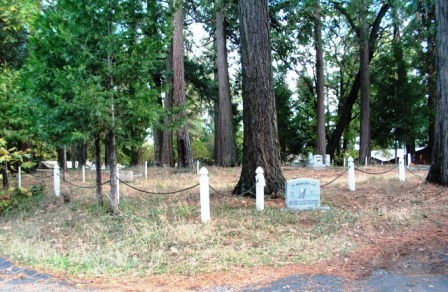
The Nine-Mile House and it's neighboring cemetery were established ca. 1857 when the State Wagon Road was established over the Sierra Nevada Mountains between Placerville, El Dorado County, California and the town of Genoa in Nevada. In 1887, the Federal land patent to 160 acres of land on which the Nine Mile House Cemetery was located, was issued to Thomas Hartwick. The cemetery continues to be used by the public to the present day. The cemetery appears to receive no formal maintenance. Many graves are marked only by the temporary markers used by the Funeral Homes and a number of graves are unmarked.
Directions for Getting There:
From Hwy 50, on the east side of Camino, take the Pony Express Trail exit. Go north under the freeway to the frontage road on the right which is Pony Express Trail. Stay on Pony Express Trail until you come to Crystal Springs Road where you will turn left. After a couple hundred yards there is a paved driveway to the right which leads up to the cemetery. Even though leading to neighboring houses, this is the public access to the cemetery.
History:
The Nine-Mile House and it's neighboring cemetery were established ca. 1857 when the State Wagon Road was established over the Sierra Nevada Mountains between Placerville, El Dorado County, California and the town of Genoa in Nevada. In 1887, the Federal land patent to 160 acres of land on which the Nine Mile House Cemetery was located, was issued to Thomas Hartwick. The cemetery continues to be used by the public to the present day. The cemetery appears to receive no formal maintenance. Many graves are marked only by the temporary markers used by the Funeral Homes and a number of graves are unmarked.
Directions for Getting There:
From Hwy 50, on the east side of Camino, take the Pony Express Trail exit. Go north under the freeway to the frontage road on the right which is Pony Express Trail. Stay on Pony Express Trail until you come to Crystal Springs Road where you will turn left. After a couple hundred yards there is a paved driveway to the right which leads up to the cemetery. Even though leading to neighboring houses, this is the public access to the cemetery.
Nearby cemeteries

Camino, El Dorado County, California, USA
- Total memorials40
- Percent photographed75%
- Percent with GPS0%

Newtown, El Dorado County, California, USA
- Total memorials53
- Percent photographed81%
- Percent with GPS0%

Pleasant Valley, El Dorado County, California, USA
- Total memorials346
- Percent photographed88%
- Percent with GPS11%

Placerville, El Dorado County, California, USA
- Total memorials6
- Percent photographed0%
- Percent with GPS0%
- Added: 5 Jul 2005
- Find a Grave Cemetery ID: 2147610

Cemetery Photos
This is a carousel with slides. Use Next and Previous buttons to navigate, or jump to a slide with the slide dots. Use Escape keyboard button or the Close button to close the carousel.


Success
Uploading...
Waiting...
Failed
This photo was not uploaded because this cemetery already has 20 photos
This photo was not uploaded because you have already uploaded 5 photos to this cemetery
This photo was not uploaded because you have already uploaded 5 photos to this cemetery
Invalid File Type
Birth and death years unknown.
1 photo picked...
2 photos picked...
Uploading 1 Photo
Uploading 2 Photos
1 Photo Uploaded
2 Photos Uploaded
Size exceeded
Too many photos have been uploaded
"Unsupported file type"
• ##count## of 0 memorials with GPS displayed. Double click on map to view more.No cemeteries found