Long Society Congregational Burying Ground
Preston, New London County, Connecticut, USA
About
-
- Cemetery ID:
Members have Contributed
Advertisement
Photos


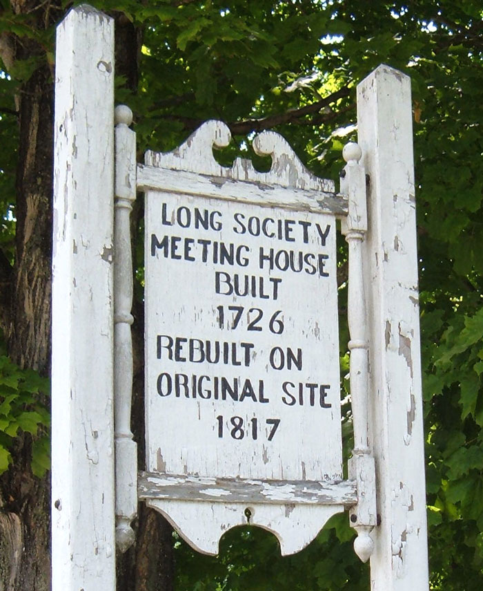
Long Society (Congregational) Derived its name from its location on the long, narrow strip of land east of the Thames and Shetucket rivers which formed the eastern boundary of the original town of Norwich (then nine miles square), and extended from the present village of Poquetanuck to that of Plainfield. The church was organized in 1726, under the pastoral care of the Rev, Jabez Wight. The first meeting-house of the society stood where to-day stands its successor, about three miles from the centre of the city of Norwich. The church yard, from which many of the older gravestones have disappeared, lies immediately in the rear and on both sides of the meeting-house. When Norwich was divided, in 1786, Long Society became a part of Preston.
Long Society (Congregational) Derived its name from its location on the long, narrow strip of land east of the Thames and Shetucket rivers which formed the eastern boundary of the original town of Norwich (then nine miles square), and extended from the present village of Poquetanuck to that of Plainfield. The church was organized in 1726, under the pastoral care of the Rev, Jabez Wight. The first meeting-house of the society stood where to-day stands its successor, about three miles from the centre of the city of Norwich. The church yard, from which many of the older gravestones have disappeared, lies immediately in the rear and on both sides of the meeting-house. When Norwich was divided, in 1786, Long Society became a part of Preston.
Nearby cemeteries

Norwich, New London County, Connecticut, USA
- Total memorials446
- Percent photographed92%
- Percent with GPS1%

Preston, New London County, Connecticut, USA
- Total memorials13
- Percent photographed38%
- Percent with GPS0%
Norwich, New London County, Connecticut, USA
- Total memorials221
- Percent photographed88%
- Percent with GPS17%

Norwich, New London County, Connecticut, USA
- Total memorials80
- Percent photographed100%
- Percent with GPS1%
- Added: 22 Apr 2004
- Find a Grave Cemetery ID: 1982521

Cemetery Photos
This is a carousel with slides. Use Next and Previous buttons to navigate, or jump to a slide with the slide dots. Use Escape keyboard button or the Close button to close the carousel.


Success
Uploading...
Waiting...
Failed
This photo was not uploaded because this cemetery already has 20 photos
This photo was not uploaded because you have already uploaded 5 photos to this cemetery
This photo was not uploaded because you have already uploaded 5 photos to this cemetery
Invalid File Type
Birth and death years unknown.
1 photo picked...
2 photos picked...
Uploading 1 Photo
Uploading 2 Photos
1 Photo Uploaded
2 Photos Uploaded
Size exceeded
Too many photos have been uploaded
"Unsupported file type"
• ##count## of 0 memorials with GPS displayed. Double click on map to view more.No cemeteries found