Columbus Air Force Base Cemetery
Also known as Andrews Chapel Cemetery , Greer Family Cemetery
Lowndes County, Mississippi, USA

Originally started by the Greer family - 1st recorded death here was 1824 (Susannah Greer). Remember this was when the lands to the west of the Tombigbee were still territories of the Choctaw and Chickasaw Indians. Lots of history here. It was thought to be part of Alabama, then became Monroe county before Lowndes county was formed in 1830.
Around the turn of the century (1900's) The Andrews Chapel neighborhood continued as a thriving community known as "Dutch" (post office operating at the old Cox plantation). The Barton-Vinton ferry crossing was the route of the Columbus-Aberdeen stagecoach.
It was situated approx 9 miles north of Columbus on the (old) Aberdeen Road at the Lowndes, Monroe, and Clay Counties lines on the banks of the Tombigbee and Buttahatchie Rivers and in close proximity to Kolola Springs, MS.
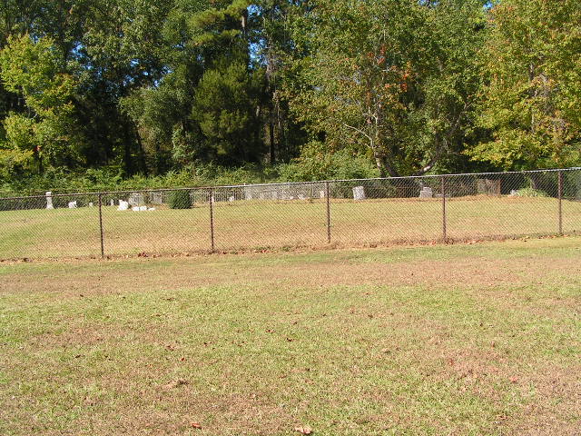
Today the Columbus Air Force Base encompasses the cemetery within its grounds. The CAFB routinely mows/cleans it but does not use it for Military purposes. A great number of stones became broken or missing so they fenced it in with locked gates to protect the few stones that remain from vandalism. Visitors are welcome by appointment.
Before the CAFB was established here, this was a thriving community of plantations, and farmers with a church, postal service, schoolhouse, and a busy ferry crossing the Tombigbee River. The Barton-Vinton ferry was situated on the route of the Columbus-Aberdeen stagecoach.
Originally started by the Greer family - 1st recorded death here was 1824 (Susannah Greer). Remember this was when the lands to the west of the Tombigbee were still territories of the Choctaw and Chickasaw Indians. Lots of history here. It was thought to be part of Alabama, then became Monroe county before Lowndes county was formed in 1830.
Around the turn of the century (1900's) The Andrews Chapel neighborhood continued as a thriving community known as "Dutch" (post office operating at the old Cox plantation). The Barton-Vinton ferry crossing was the route of the Columbus-Aberdeen stagecoach.
It was situated approx 9 miles north of Columbus on the (old) Aberdeen Road at the Lowndes, Monroe, and Clay Counties lines on the banks of the Tombigbee and Buttahatchie Rivers and in close proximity to Kolola Springs, MS.
Today the Columbus Air Force Base encompasses the cemetery within its grounds. The CAFB routinely mows/cleans it but does not use it for Military purposes. A great number of stones became broken or missing so they fenced it in with locked gates to protect the few stones that remain from vandalism. Visitors are welcome by appointment.
Before the CAFB was established here, this was a thriving community of plantations, and farmers with a church, postal service, schoolhouse, and a busy ferry crossing the Tombigbee River. The Barton-Vinton ferry was situated on the route of the Columbus-Aberdeen stagecoach.
Nearby cemeteries

Columbus, Lowndes County, Mississippi, USA
- Total memorials46
- Percent photographed11%
- Percent with GPS0%
Lowndes County, Mississippi, USA
- Total memorials3
- Percent photographed0%
- Percent with GPS0%
West Point, Clay County, Mississippi, USA
- Total memorials15
- Percent photographed87%
- Percent with GPS0%

Clay County, Mississippi, USA
- Total memorials70
- Percent photographed67%
- Percent with GPS0%
- Added: 6 Oct 2003
- Find a Grave Cemetery ID: 1971377

Cemetery Photos
This is a carousel with slides. Use Next and Previous buttons to navigate, or jump to a slide with the slide dots. Use Escape keyboard button or the Close button to close the carousel.

Success
Uploading...
Waiting...
Failed
This photo was not uploaded because this cemetery already has 20 photos
This photo was not uploaded because you have already uploaded 5 photos to this cemetery
This photo was not uploaded because you have already uploaded 5 photos to this cemetery
Invalid File Type
Birth and death years unknown.
1 photo picked...
2 photos picked...
Uploading 1 Photo
Uploading 2 Photos
1 Photo Uploaded
2 Photos Uploaded
Size exceeded
Too many photos have been uploaded
"Unsupported file type"
• ##count## of 0 memorials with GPS displayed. Double click on map to view more.No cemeteries found