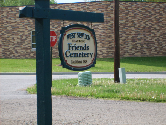
Easton Friends Cemetery
Also known as West Newton Friends Cemetery
West Newton, Marion County, Indiana, USA
About
-
- Cemetery ID:
Members have Contributed
Advertisement


DIRECTIONS:
Exit-465 at Kentucky Ave. on the southwest side of Marion County. Turn left onto Kentucky Ave. and go southeast .3 miles to High School Road, (turn left at the McDonald's)and go south 2.8 miles (after 1 mile, High School Rd. becomes Mooresville Rd) to Quaker Road.
The cemetery is on the right side of Mooresville Road at the intersection, across from the West Newton Elementary School. Parking is on the side of the road, or in the nearby school parking lot.
Nearby cemeteries

West Newton, Marion County, Indiana, USA
- Total memorials5k+
- Percent photographed83%
- Percent with GPS5%

West Newton, Marion County, Indiana, USA
- Total memorials270
- Percent photographed76%
- Percent with GPS21%

Morgan County, Indiana, USA
- Total memorials19
- Percent photographed42%
- Percent with GPS0%

Landersdale, Morgan County, Indiana, USA
- Total memorials16
- Percent photographed100%
- Percent with GPS75%
- Added: 1 Jan 2000
- Find a Grave Cemetery ID: 85073

Cemetery Photos
This is a carousel with slides. Use Next and Previous buttons to navigate, or jump to a slide with the slide dots. Use Escape keyboard button or the Close button to close the carousel.


Success
Uploading...
Waiting...
Failed
This photo was not uploaded because this cemetery already has 20 photos
This photo was not uploaded because you have already uploaded 5 photos to this cemetery
This photo was not uploaded because you have already uploaded 5 photos to this cemetery
Invalid File Type
Birth and death years unknown.
1 photo picked...
2 photos picked...
Uploading 1 Photo
Uploading 2 Photos
1 Photo Uploaded
2 Photos Uploaded
Size exceeded
Too many photos have been uploaded
"Unsupported file type"
• ##count## of 0 memorials with GPS displayed. Double click on map to view more.No cemeteries found