Silver Valley Cemetery
Silver Valley, Coleman County, Texas, USA
About
-
- Cemetery ID:
Members have Contributed
Advertisement
Photos


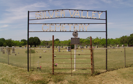
The Silver Valley Cemetery is located about one-half mile north of the Silver Valley intersection on US 84. This is a chain link fenced, well-kept cemetery with drive in gates on the south and east sides and a walk-in gate on the east side. Most cement pavers and other markers were in evidence when an inscription survey of the Silver Valley Cemetery was made by Judia and Ralph Terry and Vena Bob Gates in 1988. Sometime in the 1990s, white painted metal crosses were added to these cement pavers, most made of rebar. Two crosses, near the southeast corner, were made of metal tubing. In 2005, I built a website for Silver Valley Cemetery, located at , and added pictures of each marker. When I began this map and survey in 2023, two additional tubing crosses were noted, one marking a reserved space south of the grave of Russel Dean Johnson, and the other marking a cement slab at Memorial 239, which was not at this location in 2005. There are many family lots at Silver Valley Cemetery, many of which are curbed. Some of these curbs are now covered with soil.
In 2008, I was told the land George Baker had given for a school, where a cemetery was later established, was at the Silver Valley Cemetery, rather than Mount View Cemetery. Apparently, no deeds were made of this land donation. It was also stated that Robinson Peak was not where it is located today, but was a peak near Silver Valley, and this is the reason Silver Valley Cemetery was first called Robinson Peak Cemetery. This is possible, but I find no reason to accept this, as no Bakers are buried at Silver Valley Cemetery. At least one child of George Baker, as well as George's brother, William and his family are buried at Mount View Cemetery, with marked graves. George Baker died in San Antonio in 1923 and is probably buried there. The earliest marked grave at Mount View Cemetery is that of Martha C. Baker (died January 21, 1891), wife of William B. Baker, the brother of George Baker. It makes sense to me that she would be buried near where they lived. Perhaps she was buried on George's land, but no actual land donation was ever made. George and his brother, William lived only two houses apart in Justice Precinct No. 4, when the 1900 Coleman County census was taken. In other words, the Baker family appears to have been associated with the Mount View area, rather than the Silver Valley area. Another problem encountered while building an index for Silver Valley Cemetery is some early 1900 death certificates shown Silver Valley Cemetery as the place of burial, but tombstones for them are at Mount View Cemetery. Therefore, some burials shown at Silver Valley may actually be at Mount View. The Silver Valley Cemetery and the Mount View Cemetery are only a bit over three miles apart, in a straight line.
The earliest marked grave at Silver Valley Cemetery was in 1881 and is that of Helen Averitt, wife of John C. Averitt, a minister, so the Silver Valley Cemetery appears to have been established before Mount View. There were no other marked graves at Silver Valley Cemetery until 1884. I have wondered why the Averitts were in this area, if not to start a church. There were no established communities at Mount View or Silver Valley until 1909. The original beginning of Silver Valley, known as "Old" Silver Valley when "New" Silver Valley was began, was a few miles to the southwest.
During the creation of the 2023 Silver Valley Cemetery map and indices, I have added pictures, memorial numbers and locations, as given in these indices, to each person buried at the Silver Valley Cemetery, and each can be viewed on FindAGrave.com. I have also added the 2023 map in the photo section of the Silver Valley Cemetery on FindAGrave and each memorial can be located on the map and in the cemetery using the memorial number and map coordinates. Verses, marriage dates, military service information, lodge affiliation, and other genealogical type inscriptions shown on markers were not included in these indices, as they were made for use by the cemetery association as a guide to grave location and space allocation and not as a genealogical reference. If this information is needed, please consult that person's memorial on the FindAGrave.com website.
Some graves have markers which are shared; that is, the marker contains the names and information of two persons or more, usually a husband and wife. The surname, which usually appears on this type marker only once, has been shown before each person's name for identification in these indices. The map will indicate two reference numbers, when there are two graves, but only one marker. I have also placed reference numbers for reserved graves when there is a marker in place with names inscribed or have been reported to and recorded by the Silver Valley Cemetery Association. We have done this because sometimes it cannot be verified if the person is living, or if the person is deceased with no death date inscribed. There are cases of markers being placed and both persons are still living. These reserved spaces have also been given a reference number.
This map was not drafted to scale. A vertical aerial photograph was initially used to determine the locations of the fence, curbs and larger tombstones, then a field survey was done for accuracy. Details such as widths of curbs, exact size of markers, and exact variations of rows off true north to south and east to west alignment are not indicated. Curbs have been drawn as narrow lines. The outside fence of the cemetery has been shown as a broader line. Grave markers are shown as lines of varying lengths, depending on the size of the grave marker, but are not to scale. Temporary markers, such as cement pavers and funeral home markers (FHM) have been shown as short lines, whether known or unknown. Unknown graves were marked before 1988 with cast cement pavers set in the ground. In the 1990s white painted metal rebar (in most cases) crosses were set in the ground behind these cement pavers. In 2005, I created a website, with pictures of all the stones and locations of graves, of the Silver Valley Cemetery (located at nbsp; I noted at that time that 2 crosses made of metal tubing at the southeast corner of the cemetery. Both types of white metal crosses are shown on this map as crosses (plus signs).
In creating these indices and map for the Silver Valley Cemetery Association in 2023, 2 additional white pained tubing crosses were found in the cemetery that had not be noted previously. One was apparently marking a reserved place to the south of Russell Dean Johnson. The second tubing marker was 6 feet to the south of a cement slab (now Map #239). In 1988, no grave was found at this location, so I have assumed it was to mark Map #239. I have moved the metal cross to this cement slab. One grave marked with a cement paver in 1988 was not found in 2023 (Map 344). It is located on a north to south line between the tombstones of Jim Thomas Sanders (Map #149) and Henry Dee Smith (Map #159). It could have been where the Copeland and Martin graves are now located. (from Ralph Terry)
Nearby cemeteries

Silver Valley, Coleman County, Texas, USA
- Total memorials6
- Percent photographed83%
- Percent with GPS0%
Silver Valley, Coleman County, Texas, USA
- Total memorials2
- Percent photographed0%
- Percent with GPS0%

Silver Valley, Coleman County, Texas, USA
- Total memorials7
- Percent photographed100%
- Percent with GPS0%

Coleman County, Texas, USA
- Total memorials258
- Percent photographed86%
- Percent with GPS6%
- Added: 1 Jan 2000
- Find a Grave Cemetery ID: 6916

Cemetery Photos
This is a carousel with slides. Use Next and Previous buttons to navigate, or jump to a slide with the slide dots. Use Escape keyboard button or the Close button to close the carousel.


Success
Uploading...
Waiting...
Failed
This photo was not uploaded because this cemetery already has 20 photos
This photo was not uploaded because you have already uploaded 5 photos to this cemetery
This photo was not uploaded because you have already uploaded 5 photos to this cemetery
Invalid File Type
Birth and death years unknown.
1 photo picked...
2 photos picked...
Uploading 1 Photo
Uploading 2 Photos
1 Photo Uploaded
2 Photos Uploaded
Size exceeded
Too many photos have been uploaded
"Unsupported file type"
• ##count## of 0 memorials with GPS displayed. Double click on map to view more.No cemeteries found