Greenwood Cemetery
Also known as Bradwardine Methodist Cemetery
Harding, Virden Census Division, Manitoba, Canada
About
-
Get directions 135500 Provincial Road 68N
Harding, RM of Wallace-Woodworth, Manitoba
R0M 0V0 CanadaCoordinates: 50.00471, -100.56531 - www.wallace-woodworth.com/p/greenwood-cemetery
- [email protected]
- +1-204-748-1239
-
Office Address
154023-PR 257
PO Box 2200
Virden, Manitoba
R0M 2C0 Canada - Cemetery ID:
-
Additional information
Located on the north side of Provincial Range Road 68N, about midway between Provincial Roads 135W and 136W
There is normally no vehicular access to the grounds
For queries about burials in this cemetery, the current caretakers of the site can be reached using the information on the RM of Wallace-Woodworth's website
NOTE: The RM of Wallace-Woodworth offers an interactive map of this cemetery on their website
Members have Contributed
Advertisement
Photos


After district meetings, a land parcel was purchased from G. Clenndenning in 1890 and the first cemetery lots were sold. An additional 0.5 acres of land adjacent to Greenwood Cemetery was purchased in 1903, while another 1.5 acres to the west was purchased in 1954.
It was on this property that the Bradwardine Methodist Church was later constructed in the fall of 1892. In 1905, the church building was moved to Harding by horses.
(Source: RM of Wallace-Woodworth website [2023/10; Adapted])
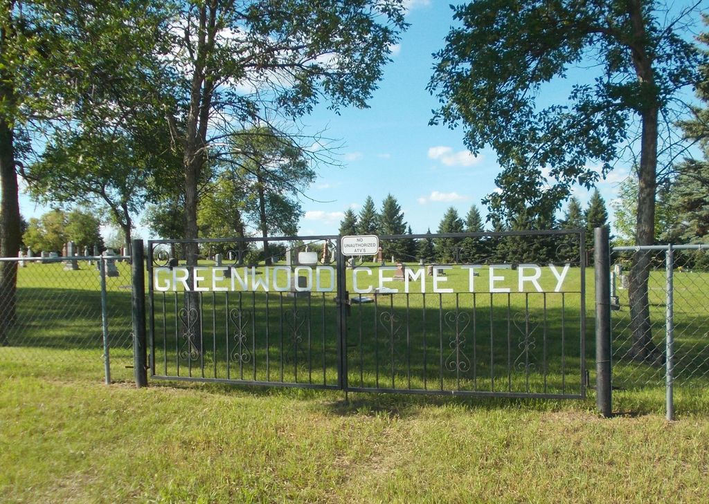
This is an old cemetery, not manicured but looked after, with original prairie sod and maple trees along the edge and scattered throughout. It is open to the north.
It has a page-wire fence and a page-wire gate with the name and dates 1890 and 1913. There is another entry gate along the west side that opens to a road and utility shed. Two rows of fir trees have been planted. There are several enclosed family plots.
(Source: Manitoba Genealogical Society [Adapted])
Dominion Land Survey coordinates: LSD02-16-12-23-W1
A part of the town's story and those of its inhabitants from the early days of European settlement through roughly 1981 is told in the volume "Home to Harding 1879-1981", especially starting on page 63. A free digital version of this and many other Manitoba local history books can be found online in the University of Manitoba Digital Collections. There is also a list of such books organized by district and town name on the Manitoba Historical Society's website on their page entitled "Finding Aid: Manitoba Local History Books".
A list of burials in this cemetery is available from the Manitoba Genealogical Society (reference #0064), transcribed by a member or members in 1980. Also available to MGS members is a searchable online database named the "MGS Manitoba Name Index" (or MANI). Some additional information is contained in the 1996 MGS publication "Carved in Stone: Manitoba Cemeteries and Burial Sites" (revised edition, Special Projects Publication, 106 pages).
After district meetings, a land parcel was purchased from G. Clenndenning in 1890 and the first cemetery lots were sold. An additional 0.5 acres of land adjacent to Greenwood Cemetery was purchased in 1903, while another 1.5 acres to the west was purchased in 1954.
It was on this property that the Bradwardine Methodist Church was later constructed in the fall of 1892. In 1905, the church building was moved to Harding by horses.
(Source: RM of Wallace-Woodworth website [2023/10; Adapted])
This is an old cemetery, not manicured but looked after, with original prairie sod and maple trees along the edge and scattered throughout. It is open to the north.
It has a page-wire fence and a page-wire gate with the name and dates 1890 and 1913. There is another entry gate along the west side that opens to a road and utility shed. Two rows of fir trees have been planted. There are several enclosed family plots.
(Source: Manitoba Genealogical Society [Adapted])
Dominion Land Survey coordinates: LSD02-16-12-23-W1
A part of the town's story and those of its inhabitants from the early days of European settlement through roughly 1981 is told in the volume "Home to Harding 1879-1981", especially starting on page 63. A free digital version of this and many other Manitoba local history books can be found online in the University of Manitoba Digital Collections. There is also a list of such books organized by district and town name on the Manitoba Historical Society's website on their page entitled "Finding Aid: Manitoba Local History Books".
A list of burials in this cemetery is available from the Manitoba Genealogical Society (reference #0064), transcribed by a member or members in 1980. Also available to MGS members is a searchable online database named the "MGS Manitoba Name Index" (or MANI). Some additional information is contained in the 1996 MGS publication "Carved in Stone: Manitoba Cemeteries and Burial Sites" (revised edition, Special Projects Publication, 106 pages).
Nearby cemeteries

Kenton, Virden Census Division, Manitoba, Canada
- Total memorials203
- Percent photographed96%
- Percent with GPS10%

Bradwardine, Brandon Census Division, Manitoba, Canada
- Total memorials227
- Percent photographed96%
- Percent with GPS7%

Bradwardine, Brandon Census Division, Manitoba, Canada
- Total memorials289
- Percent photographed99%
- Percent with GPS19%

Oakner, Western Manitoba Census Division, Manitoba, Canada
- Total memorials51
- Percent photographed100%
- Percent with GPS2%
- Added: 28 Oct 2012
- Find a Grave Cemetery ID: 2471016

Cemetery Photos
This is a carousel with slides. Use Next and Previous buttons to navigate, or jump to a slide with the slide dots. Use Escape keyboard button or the Close button to close the carousel.


Success
Uploading...
Waiting...
Failed
This photo was not uploaded because this cemetery already has 20 photos
This photo was not uploaded because you have already uploaded 5 photos to this cemetery
This photo was not uploaded because you have already uploaded 5 photos to this cemetery
Invalid File Type
Birth and death years unknown.
1 photo picked...
2 photos picked...
Uploading 1 Photo
Uploading 2 Photos
1 Photo Uploaded
2 Photos Uploaded
Size exceeded
Too many photos have been uploaded
"Unsupported file type"
• ##count## of 0 memorials with GPS displayed. Double click on map to view more.No cemeteries found