Mariekirkens ruin
Also known as Church of St. Mary ruins
Oslo, Oslo kommune, Oslo fylke, Norway
About
-
Get directions Middelalderparken
Oslo, Oslo kommune, Oslo fylke 0150 NorwayCoordinates: 59.90345, 10.76212 - Cemetery ID:
Members have Contributed
Advertisement
Photos
No additional photos.
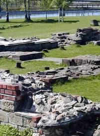
Add PhotosThe Church of St. Mary burned in 1523, and in 1542 the burnt and dilapidated church was demolished. And after the big fire in Oslo in 1624, the city, on the order of King Christian IV, was rebuilt on the other side of Bjørvika - under the protection of Akershus fortress and under the name Christiania. Then the ruins of St. Mary's Church in old Oslo were covered with soil and used for cultivation. Eventually, the buried medieval city of Oslo went into oblivion, as a "Pompeii of the North".
September 1, 1854, Norway's first railway line was opened between Christiania and Eidsvoll. When the railroad in the 1870s was to lay a new track eastward from Christiania, the train line was planned where archaeologists feared that the ruins of the Church of Mary were hidden. It was not easy to get permission for excavation from the railway company, but in the end, they said yes - and the Church of Mary was found in 1868. This did not stop the railway and the development continued; the train tracks were laid around the ruin.
Two excavations later and a new respect for past history led to the municipality of Oslo purchasing the entire Sørenga area by the state, removing the railway tracks in front of the church and making what we today known as the Medieval Park (Middelalderparken) - it is a park area in the Old Oslo district. The park is located south of Bispegata and east of Sørenggata, down towards the harbor. It was built in 1999 and opened in 2000. The purpose was to give better access to, and a more dignified framework around, medieval ruins. The park is a total of (70 dekar) 17,3 acres (US/UK).
Middelalderparken (The Medieval Park), Minneparken (The Memory Park) (St. Hallward's Cathedral) and Oslo Ladegård thus make up the Nordic region's largest continuous preserved ruin area. Here are several ruins. A water level has been built in the medieval park, marking Alnaelva's original outlet. Down to this, parts of the shoreline from the Middle Ages have been reconstructed.
The Church of St. Mary burned in 1523, and in 1542 the burnt and dilapidated church was demolished. And after the big fire in Oslo in 1624, the city, on the order of King Christian IV, was rebuilt on the other side of Bjørvika - under the protection of Akershus fortress and under the name Christiania. Then the ruins of St. Mary's Church in old Oslo were covered with soil and used for cultivation. Eventually, the buried medieval city of Oslo went into oblivion, as a "Pompeii of the North".
September 1, 1854, Norway's first railway line was opened between Christiania and Eidsvoll. When the railroad in the 1870s was to lay a new track eastward from Christiania, the train line was planned where archaeologists feared that the ruins of the Church of Mary were hidden. It was not easy to get permission for excavation from the railway company, but in the end, they said yes - and the Church of Mary was found in 1868. This did not stop the railway and the development continued; the train tracks were laid around the ruin.
Two excavations later and a new respect for past history led to the municipality of Oslo purchasing the entire Sørenga area by the state, removing the railway tracks in front of the church and making what we today known as the Medieval Park (Middelalderparken) - it is a park area in the Old Oslo district. The park is located south of Bispegata and east of Sørenggata, down towards the harbor. It was built in 1999 and opened in 2000. The purpose was to give better access to, and a more dignified framework around, medieval ruins. The park is a total of (70 dekar) 17,3 acres (US/UK).
Middelalderparken (The Medieval Park), Minneparken (The Memory Park) (St. Hallward's Cathedral) and Oslo Ladegård thus make up the Nordic region's largest continuous preserved ruin area. Here are several ruins. A water level has been built in the medieval park, marking Alnaelva's original outlet. Down to this, parts of the shoreline from the Middle Ages have been reconstructed.
Nearby cemeteries

Oslo, Oslo kommune, Oslo fylke, Norway
- Total memorials4
- Percent photographed75%
- Percent with GPS0%

Oslo, Oslo kommune, Oslo fylke, Norway
- Total memorials147
- Percent photographed86%
- Percent with GPS31%
Oslo, Oslo kommune, Oslo fylke, Norway
- Total memorials0
- Percent photographed0%
- Percent with GPS0%

Oslo, Oslo kommune, Oslo fylke, Norway
- Total memorials7
- Percent photographed86%
- Percent with GPS0%
- Added: 28 Sep 2006
- Find a Grave Cemetery ID: 2190860

Cemetery Photos
This is a carousel with slides. Use Next and Previous buttons to navigate, or jump to a slide with the slide dots. Use Escape keyboard button or the Close button to close the carousel.
Success
Uploading...
Waiting...
Failed
This photo was not uploaded because this cemetery already has 20 photos
This photo was not uploaded because you have already uploaded 5 photos to this cemetery
This photo was not uploaded because you have already uploaded 5 photos to this cemetery
Invalid File Type
Birth and death years unknown.
1 photo picked...
2 photos picked...
Uploading 1 Photo
Uploading 2 Photos
1 Photo Uploaded
2 Photos Uploaded
Size exceeded
Too many photos have been uploaded
"Unsupported file type"
• ##count## of 0 memorials with GPS displayed. Double click on map to view more.No cemeteries found